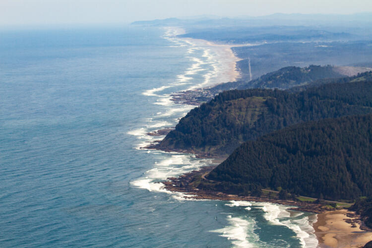
Nearshore Habitats encompass the coastal and marine habitats in the area from the 3 nautical mile outer limit of Oregon’s territorial sea, where water depths average 66 m (216 ft) and range from 17 m to 194 m (56 to 308 ft), to the supratidal areas of the shoreline affected by wave spray and overwash at extreme high tides.
Nearshore Habitats are described using the Coastal and Marine Ecological Classification Standard (CMECS) habitat classification approach (see Appendix – Marine Habitat Classification). The major habitat types found in Oregon’s nearshore, including neritic, soft bottom subtidal, rocky subtidal, rocky shore, sandy beaches. For information on estuaries, which also occur in the nearshore, see the Estuaries Key Habitat.
Characteristics
Neritic Habitat (Open Water)
The neritic habitat encompasses the waters and biological communities over the continental shelf, including nearshore and offshore marine subsystems as defined by CMECS. It spans the surface, upper water column, pycnocline, and lower water column, extending westward to the continental shelf break at about the 200 m (656 ft) depth contour. Constantly in motion, this habitat is shaped by the California Current System, seasonal upwelling and downwelling, El Niño/La Niña events, and the Pacific Decadal Oscillation, which all drive water movement across various time scales.
The CMECS biotic component identifies planktonic biota as the primary setting, with species composition varying by water mass. The ecology of the neritic habitat is affected by processes taking place at scales varying from global to local. The dynamics of the neritic habitat affect all the other habitats described later in this section.
Physical Environment
Many physical and chemical environmental factors affect neritic ecology. These factors include but are not limited to solar light and radiation influence, salinity, temperature, layer position, physical mixing, hydrostatic pressure, biogeochemical composition, atmospheric exposure and influence, surface and underwater currents, swells, waves, and water mass movements. Many of these factors can change by location and time of year. The neritic habitat encompasses many water column habitats that shift, expand, and contract over time and space in both predictable and stochastic patterns.
Coastal upwelling is perhaps the most defining feature of Oregon’s neritic habitat with its alternating upwelling-relaxation events. Upwelling is described by CMECS as an upwardly-directed current caused by divergence of water masses. In spring and summer months, strong northerly winds push surface and upper water layers westward towards the deep ocean. This movement causes deep, cold, oxygen-poor but nutrient-rich waters to rise to the surface near the coast replacing the water that was driven offshore. These nutrients, brought to the upper layers of the water column, help propagate and sustain the rich biota of Oregon’s coastal waters. The relaxation events, when the northerly winds briefly cease or reverse, allow the upper water layer to move back towards shore bringing its rich biotic content with supplies of food, larvae, and juvenile organisms. In the fall and winter months when winds blow predominantly from the south, the surface and upper water layers move shoreward and downward in a process called downwelling. Downwelling is an important part of the annual seasonal cycle that forces oxygen rich waters from the upper layers downward in the water column. Surface water temperatures provide a good indication of these seasonal wind forcing differences that bring the cold, nutrient-rich waters to the surface in the summer and the warmer waters from offshore to the coast in the winter (see Nearshore ecoregion).
Large-scale changes in water masses, temperatures and currents result in changes in plankton species composition and abundance, which impact the survival and distribution of organisms within coastal and oceanic ecosystems. These large-scale oceanic events, such as El Niño/La Niña and the Pacific Decadal Oscillation, occur at multi-year or decadal time scales.
Another water column component that affects Oregon’s neritic habitats is river plumes. CMECS does not characterize the marine waters affected by these plumes as estuarine because they are not meaningfully enclosed by landforms. Riverine waters entering the ocean often carry high concentrations of nutrients, create gradients in salinity, cause physical mixing, and create areas of high turbidity. Large river plumes, such as that from the Columbia River, may serve as a microhabitat within neritic habitats and can potentially act as biogeographic barriers between marine areas to the north and south. The Columbia River plume stretches hundreds of miles offshore and shifts predictably over the course of each year. In the summer the plume spreads south and offshore from the river’s mouth, while during the winter the plume is found to the north of the river mouth and is usually directly adjacent to the coast. This plume has important ecological effects, not only to neritic habitats, but to nearshore and offshore habitats as well. The oceanographic fronts created by the Columbia River plume in the marine systems generate productive conditions that attract many species of invertebrates, fish, seabirds, and marine mammals.
Biological Characteristics
Neritic habitats support two basic types of marine organisms: plankton and nekton. Planktonic organisms live in the water column and are incapable of swimming against currents, instead drifting with them. Plankton are often categorized as either phytoplankton or zooplankton. Phytoplankton are microscopic photosynthesizing organisms (e.g., diatoms) and are the primary producers that form the base of the marine food web. Huge surges in phytoplankton populations, known as “blooms,” are commonly associated with upwelling events. Zooplankton are heterotrophic organisms that range in size from microscopic single-celled organisms to enormous jellyfish a meter or more in diameter. Some plankton, called holoplankton, like many diatoms, copepods, krill and jellyfish spend their entire lives as drifters in the water column. Many species like sea urchins, mussels, crabs, some snails, and many fishes have planktonic stages as eggs or larva, called meroplankton, before either settling to the bottom or growing large enough to be nekton. The CMECS biotic component uses these planktonic classes and subclasses to describe the open water neritic zone. They can be further refined by taxonomic groups and communities that are dominant in any given area of interest. Dramatic changes in plankton communities occur in Oregon waters with water masses changes. For example, warm water species are brought into nearshore water with El Niño events.
In contrast, nektonic marine organisms are capable of swimming against currents and include animals such as adult crustaceans, mollusks, and vertebrates. Highly migratory and schooling species are typical of nekton in neritic habitats. Many species of invertebrates, fish, birds, and marine mammals travel and forage within this habitat.
Many nearshore Species of Greatest Conservation Need (SGCN), Watch List and commonly associated species utilize the open water neritic habitat during their life history (see Appendix – Nearshore Species). Many forage fishes such as northern anchovy, Pacific herring, topsmelt, Pacific sardine, surf smelt, Pacific sand lance and longfin smelt feed in this open water neritic habitat. Juvenile rockfish are found in the water column. Breeding birds such as Tufted Puffin and Common Murre are central place foragers that feed on the forage fish and other species while nesting. The majority of nearshore SGCN depend on this habitat for some phase of life. This is also the habitat that supports primary production by phytoplankton and secondary production by zooplankton, which is at the base of the food web for the nearshore ecosystem. Ocean currents transport and disperse larvae and juveniles of many invertebrate and fish species throughout the region.
Human Use
Human uses of the neritic habitat include commercial and recreational fishing, nonconsumptive recreational pursuits such as boating or whale watching, scientific research, commercial maritime transportation, and military operations. Development of renewable energy sources from both wind and waves is an emerging use of the neritic habitat.
Soft bottom subtidal habitat includes all of the unconsolidated substrate areas (e.g., mud, sand, granule pebbles and various mixes thereof) on the ocean bottom. Soft bottom subtidal habitats are characterized by CMECS as being within the subtidal zones of the nearshore and offshore marine subsystems. Subtidal soft bottom habitats are diverse based on distinct organism assemblages that are influenced by differences in substrate type (sand vs. mud), organic content and bottom depth. The distribution and relative abundance and mixes of these substrates are not yet well described for much of Oregon’s nearshore ocean waters.
Physical Environment
The primary substrate types in Oregon’s soft bottom subtidal areas range from sand to pebble. CMECS defines unconsolidated mineral substrates based on particle diameter. Here we consider soft bottom habitats to be composed of the various mixes defined by CMECS of particles <64 mm (2.6 in) in diameter. Because the Oregon coast is primarily an exposed, high-energy environment, most soft bottom subtidal areas are sandy. However, mud can be the more prevalent substrate type in areas receiving less energy from water movement, including isolated and sheltered areas, and deeper areas. The distribution of these unconsolidated sediment types in Oregon waters is influenced by currents in both the nearshore and offshore subsystems. Areas close to outfalls and discharge pipes would be expected to show localized differences based on the displacement of substrate and the increased availability of organic and small particulate material. The smaller the particle size, the smaller the pores (or spaces between the particles) are. Pore size dictates the amount of water and the water chemistry of the substrate, which can define what types of organisms can live in that sediment.
Biological Characteristics
Most soft bottom subtidal communities are dominated by infaunal (burrowing) invertebrates such as polychaetae worms. However, other organisms such as crustaceans, echinoderms and mollusks may be locally abundant. Common epifauna (found on the sediment surface) can include species of shrimp, crabs, snails, bivalves, sea cucumbers, and sand dollars. Dungeness crab are an important component of soft bottom subtidal communities and are found both on the surface as well as buried in the substrate. Sea pens (Ptilosarcus sp.), colonial relations to sea anemones, are common on more muddy bottoms. In some areas of the coast, shallow sandy habitats support extensive beds of dense sand dollars that may extend miles in length. Common fish in this area include several species of flatfish (e.g., sanddab, English sole, and sand sole), and important burrowing forage species such as Pacific sand lance and sandfish.
Species associated with soft bottom subtidal habitats provide a spectrum of ecosystem services. Most widespread but least apparent of these services are the nutrient cyclers: deposit feeders and microbes living within the sediments. Emergent species such as sea pens are only found in this habitat. There are a vast array of worms and other invertebrates that live in the soft subtidal bottom. Soft bottom habitats are important to many SGCN, Species of Greatest Information Need (SGIN), Watch List and other commonly associated species at various life stages (see Appendix – Nearshore Species). For example, big skate, starry flounder, sand sole, Pacific sand lance burrow or cover themselves to hide in these sediments. Gray whales feed by sifting buried amphipods from the sediments and scooping clouds of mysid shrimp from above the sediment surface sometimes at the edges of rocky reefs. Many invertebrates like razor and native littleneck clams live in the subtidal soft bottom habitat. Both juvenile and adult Dungeness crab forage here and sometimes hide in these soft sediments. The young of commercially valuable fish species can often be found here and utilize these areas as nursery habitat. The young of many species use the nearshore area for foraging and are themselves prey for larger fishes and birds. Sand lance is a particularly valuable forage species for birds, other fishes, and marine mammals. Diving birds such as the Common Murre forage for food for their young in soft bottom areas taking juvenile flat fish back to their chicks while they are nesting.
Human Use
Commercial and recreational harvest of Dungeness crab, surf perch, and species of nearshore flatfish are the principal human uses of the soft bottom subtidal habitat. Sand and mud from dredging projects are sometimes deposited over soft bottom habitats. Soft bottom subtidal habitats could also be utilized for siting renewable energy projects and their associated infrastructure. Finally, the soft bottom subtidal offers many opportunities for scientific research
Rocky subtidal habitat includes all hard substrate areas of the ocean bottom. The geologic origin substrate components include cobble and boulder in the CMECS unconsolidated mineral substrate class and bedrock and megaclasts in the rock substrate class. Anthropogenic origin hard substrates are also here. Anthropogenic reefs include any areas where hard, persistent material has been placed either purposely or accidentally by humans. Examples include rock jetties at the entrance to many bays, shipwrecks, anchoring systems for renewable energy projects, and unburied portions of underwater cables or pipelines. Rocky subtidal areas are often referred to as reefs, rocky reefs, rocky banks, pinnacles, or “hard bottom.” Rocky subtidal habitats, including both the natural and anthropogenic components, are characterized by CMECS as being within the subtidal zones of the nearshore and offshore marine subsystems. Although most areas are never exposed to air, the CMECS subtidal definition does include areas that are exposed intermittently each month when tide levels fall below the Mean Lower Low Water (MLLW) level. Rocky subtidal habitats are found in both the nearshore subsystem and offshore subsystem and some of the differences are discussed below.
Some rocky subtidal areas are extensions of shoreline rocky features such as headlands, cliffs, or rocky intertidal habitat, while others exist as isolated regions of rock surrounded by habitat with soft bottom substrate. Rocky reefs have varied topography; some may barely come above the surrounding seafloor, while others may rise from the seafloor many meters, or extend above the surface to form islands in the Territorial Sea. There are more than 1,800 islands off the coast of Oregon, the bases of which form rocky subtidal habitat.
Physical Environment
The physical characteristics of rocky subtidal habitats reflect proximity to shore, depth of the water, local seafloor geology, erosional forces, and biological influences. The geology of many rocky subtidal areas mimics the geology of adjacent landforms, often consisting of erosion-resistant basalts or metamorphic rock common in Oregon’s rocky headlands. Over geologic time, the underwater rock features have been uplifted, bent, deformed, and alternately exposed to ocean and terrestrial erosional forces as successive ice ages and geologic forces caused massive sea level changes. These forces have shaped a variety of physical habitat features within reefs, including flat rocky benches, stacks, jagged ridges, broken boulder fields, and a vast number of cracks and crevices that provide shelter and substrate to abundant life.
Oceanographic processes and features strongly influence the rocky subtidal environment. Subtidal reefs are exposed to pounding wave action, underwater currents, and the physical and chemical properties of the water. These factors in turn influence the biological community on the reefs. Generally, nearshore reefs are more exposed to wave action than offshore reefs, and the wave action is much stronger in winter than during summer. Wave action is a key factor in determining the types of organisms that can live on the very shallow reefs. Ocean currents vary widely by location, time of year, and over tidal cycles. Currents influence reefs in a variety of ways including direct erosion, sand scour or burial of reef areas, and movement of organisms to and from reefs, including plankton and larva. Large-scale or long-term variation in the ocean environment such as upwelling, seasonal current directional shifts, shifts in ocean circulation, water temperature variation, local and global weather patterns, ocean acidification, and biological processes combine to determine the ambient chemical and physical composition of the water in rocky subtidal habitats. The CMECS water column components can be used to describe important features of the waters surrounding and overlying rocky reefs that are important in shaping the biological communities which live there.
The 30 m (98 ft) depth contour is defined by CMECS as the boundary for the nearshore subsystem and the offshore subsystem. Nearshore rocky reefs differ from offshore reefs in some key physical characteristics. Light penetration is adequate to support algal life on nearshore reefs, while offshore reefs support far less algal growth. For example, kelp is only found in nearshore subsystem rocky areas. Wave action, currents, and storms produce a higher energy environment on nearshore reefs than their deeper counterparts. Organisms adapted to higher energy environments are more prevalent in the nearshore area. On some reefs, strong currents can scour and seasonally bury or expose the rocks with sand, considerably influencing the types of organisms that can utilize those rocky subtidal environments.
Biological Characteristics
Subtidal rocky reefs are known for their abundant and diverse biological communities. The variety in topography, substrate characteristics, and depths within and among rocky reefs produces a plethora of microhabitats, often within relatively small geographic areas. This in turn provides for a diversity of species adapted to life in these different microhabitats. Habitat-forming organisms, such as kelp or attached invertebrates, provide additional microhabitats used by reef species.
Most nearshore rocky reefs have rich algal, invertebrate, fish, bird, and marine mammal communities. Depending on water depth, light penetration, wave energy, and other physical and biological processes, algae and macroalgae can provide extensive or sporadic cover and food for other species in the nearshore subsystem. Algae and macroalgae include encrusting forms that grow close to the rock surface, turf forms that can create a dense layer up to a foot thick or more, subcanopy forms that provide added subsurface habitat structure, and canopy forms that create kelp “forests” which may break the surface of the water. Offshore rocky reefs in deeper water do not have kelp forests. Free-swimming (nektonic), drifting (planktonic), and attached invertebrates are common in both the nearshore and offshore rocky subtidal habitats.
Many Nearshore SGCN, SGIN, Watch List, and other commonly associated species inhabit rocky subtidal habitats (see Appendix – Nearshore Species). These include many fish as well as a wide variety of filter or suspension feeding invertebrates that attach to hard substrates such as sponges, anemones, barnacles, bryozoans, hydrozoans, tunicates, and cold-water corals. Mobile invertebrates abound here as well. Red and purple urchins and flat abalone eat algae attached to the rocks. Ochre, sunflower and other sea stars forage in subtidal rocky habitats as do crabs, shrimps, brittle stars, nudibranchs, chitons, and worms.
The diversity of producers and consumers found in the rocky subtidal creates complex food webs and interdependence among organisms. Reefs are linked to surrounding environments by ocean currents and organism movements. Reef topographic structure often slows currents, enhancing the local community’s ability to capture drifting organisms, an effect enhanced by the occasional presence of large kelp beds. Many organisms move on and off reefs, some in large-scale migrations and others in short feeding forays to other areas. While most nearshore reef fishes occupy both nearshore and offshore reefs, there are differences in depth preferences of some species and life history stages.
Several fish species depend on nearshore rocky reefs during early life history stages before moving off to deeper reefs, the continental shelf, or other areas as they grow. Conversely, some fish depend on estuaries or rocky intertidal habitat for early life history stages before moving to rocky subtidal areas as adults. For example, kelp greenling, cabezon, and grass rockfish tend to be more prevalent on the nearshore reefs. Canary and yelloweye rockfish move from nearshore to offshore reefs as they grow. Many fish species are entirely dependent on reefs for parts of their life cycle, while others are visitors. Common visitors include herring, smelt, sharks, ratfish, and salmon.
Ecological linkages within and between rocky subtidal habitats help to shape their biological communities and the diversity of species found in this type of habitat. Currents bring in planktonic organisms and transport drifting larvae to and from disparate rocky subtidal habitats. The location of reefs with respect to other “upstream” or “downstream” reefs has a dramatic effect on the types, abundance, and recruitment rates of the reef’s communities and organisms. This complexity of organism interrelationships makes the outcome of natural or human disturbance to reefs difficult to measure or predict.
Kelp beds form a small but important subset of Oregon’s rocky subtidal habitat. CMECS classifies kelp beds as a biotic component of Oregon’s rocky subtidal habitat, and more specifically as canopy-forming algal beds. Kelp canopies in Oregon consist almost exclusively of bull kelp (Nereocystis luetkeana), a brown macroalgae that grows from the seafloor to the ocean surface and forms a floating canopy, though a few locations have historically featured small amounts of giant kelp (Macrocystis pyrifera). The strip of coast from Cape Arago south has historically contained approximately 92 percent of the state’s kelp beds (Figures 1 and 2). Kelp canopies are relatively scarce habitats in Oregon’s waters, covering less than one percent of the nearshore area. This distribution is driven historically by the locations of subtidal rocky seafloor shallow enough for sufficient light penetration to support kelp growth. More recently, the even more limited distribution reflects reductions in the total abundance of kelp in response to changes in oceanographic stressors such as warming ocean temperatures, marine heat waves, changes in ocean chemistry associated with climate change (kelps need cool, nutrient-rich waters to thrive) and recent increases in populations of grazing sea urchins (see Specialized and Local Habitats – Kelp Beds).
The presence and attributes of kelp beds depend on a number of physical and biological variables. The primary variables determining where kelp might exist include water depth and substrate availability. In Oregon’s waters, kelp beds only form on rocky substrate and are limited to the nearshore subsystem. Low light levels on the seafloor also limit the growth of kelp. However, depth, light, and substrate are not the only limiting factors; many rocky reefs in the appropriate depth range rarely or never support kelp beds. Factors that may limit kelp on these reefs include seasonal sand burial of the reef, sand scour of the rocks, overexposure to wave and storm energy, locally high turbidity, lack of nutrients, distance of the reef to “seeding” sources of kelp, abundance of organisms that consume kelp (e.g., sea urchins), and competition with invertebrates and other algae for rock substrate available for attachment. Kelp beds in Oregon display pronounced seasonal and annual variation in extent and density. Bull kelp beds grow rapidly in spring and summer, followed by a winter period when storms dislodge much of the algae, leaving little or no surface canopy. The biomass of kelp beds can also vary ten-fold or more from year to year due to interannual variation in the combinations of physical and biological variables that affect their growth.
Kelp beds are biologically rich habitats due to both the primary productivity of the kelp and the effect kelp beds have on the surrounding environment. Bull kelp is one of the fastest growing organisms in the world, annually providing a large biomass available for consumption directly or as detritus after the kelp dies. Kelp furnishes a vertical habitat structure that otherwise would not exist on the reef. Kelp beds also slow water currents and reduce waves and wind chop, helping to trap drifting larva and nutrients and providing shelter. Kelp beds and their canopies can also support a rich understory of algal and attached invertebrate cover. On Oregon reefs, dense understory algae coverage gives way to dominant invertebrate cover at about 5 to 10 m (16 to 32 ft) water depth. Thick kelp cover reduces light penetration and can limit the density of understory algae. The kelp bed and underlying reef support a diverse array of fish and invertebrate species and provide cover and foraging areas for diving seabirds and marine mammals. In Oregon, the mix of fish species on kelp bed and non-kelp bed reefs is similar, reflecting a lack of kelp-specialist fish species that is perhaps unsurprising given the relatively low proportion of Oregon’s rocky seafloor that is covered in kelp canopy.
Sea otters (Enhydra lutris) were once a common and prominent part of kelp forest communities in Oregon. Sea otter populations once extended all the way from northern Japan and the Aleutian Islands of Alaska, south to the midpoint of the Pacific coast of Baja California, Mexico. Sea otters are now largely absent from Oregon coastal waters, due to overexploitation in the commercial fur trade. Commercial trade for sea otter pelts began in 1741 and by the early twentieth century, sea otters were approaching extinction throughout their range. An international treaty was signed in 1911, to ban hunting of sea otters, by which time populations had already disappeared from Oregon’s waters. Sea otters are considered “keystone species” that exhibit important effects on the characteristics of nearshore biological communities. Sea otters consume herbivorous invertebrates, such as sea urchins, which then allow secondary development of dense algal populations, including kelps. Sea otters are managed by the United States Fish and Wildlife Service. As of 2025, efforts were underway to research the possibility of reintroduction and restoration of sea otter populations to Oregon coastal waters. This effort is being undertaken by the Elakha Alliance, an informal association of tribes, universities, agencies, organizations, and individuals.
Human Use
Human uses of nearshore rocky reefs include fishing, scientific research, sightseeing, and a number of other recreational and industrial pursuits. Commercial and recreational fishing for many types of rockfish species, lingcod, cabezon, and kelp greenling are the primary human uses of this habitat to date. SCUBA diving and underwater photography are among the other less prevalent uses. Much of the commercial live fish fishery takes place on shallow nearshore reefs. Recreational anglers also favor shallow nearshore reefs, if they are available. Commercial fishing targeting nearshore species tend to be higher on the south coast and recreational effort more prevalent on the north coast. Many reefs are used recreationally by SCUBA divers, sea kayakers, boaters, and surfers. Reefs with extensive kelp beds and islands provide sightseeing and bird watching opportunities for coastal residents and visitors. However, many reefs have no features extending to the ocean surface, and thus many people are unaware of the teeming life existing just below the water’s surface.
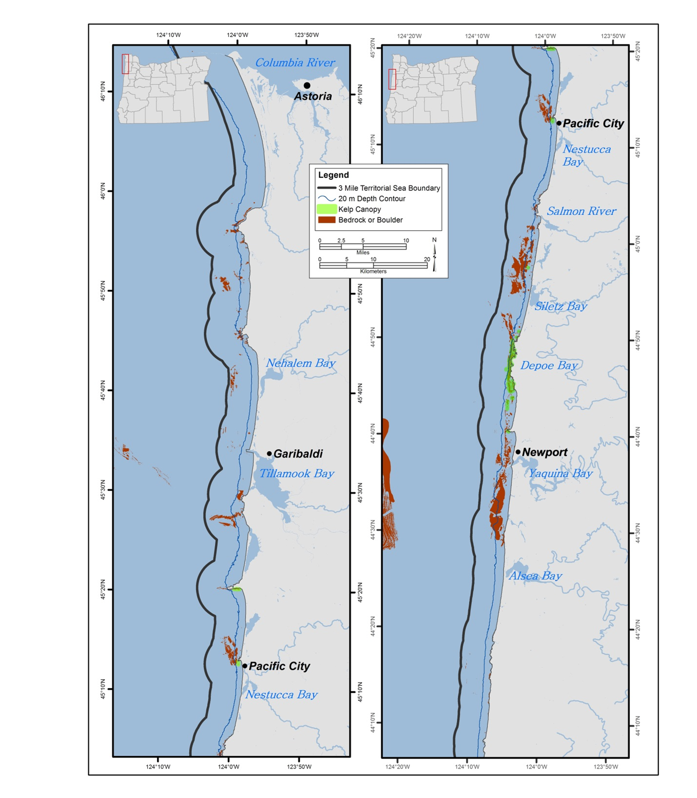
Photo Credit: ODFW.
Figure 1. Maximum historical extent of kelp beds along the north Oregon coast.
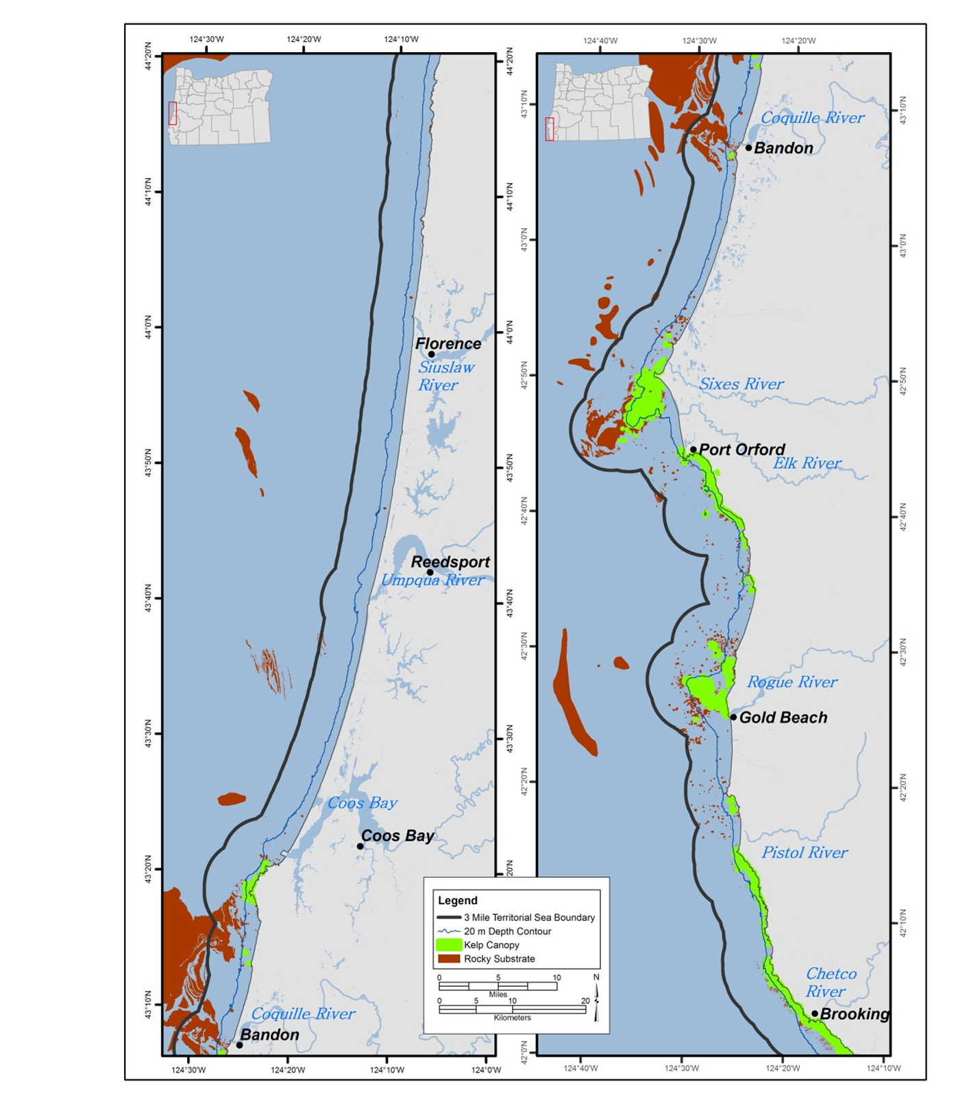
Photo Credit: ODFW.
Figure 2. Maximum historical extent of kelp beds along the south Oregon coast.
Rocky Shore
Oregon’s rocky shores, often referred to as rocky intertidal or tidepool areas, form parts of the shoreward boundary of the nearshore planning area and can extend from the extreme low tide to the extreme high tide. They are characterized by CMECS as marine nearshore areas in the Intertidal and Supratidal zones, which include all hard substrate areas along the shoreline that are alternately exposed and covered by tides or are affected by wave splash and overwash, but not areas affected only by wind-driven spray. Everything beyond the reach of ocean waves is considered terrestrial habitat. The substrates making up Oregon’s rocky shores include both volcanic and sedimentary bedrock as well as megaclasts, boulder, cobble and human-made (anthropogenic) structures. Some rocky shore areas are extensions of other shoreline rocky features such as headlands or cliffs, others exist as isolated regions of rock surrounded by sandy beach habitat, and some are anthropogenic in origin, having been deposited intentionally or unintentionally by humans. Oregon’s coastline has approximately 152 linear miles of rocky shore habitat, and some 20 miles of jetties.
An example of a naturally occurring geoform component found in Oregon’s rocky shores would be a tidepool. Some of the anthropogenic geoforms found in Oregon’s rocky shores include breakwaters, jetties, and rip rap deposits. All rocky shore habitats in Oregon are contained entirely within the SWAP’s planning area.
Physical Environment
The physical characteristics of rocky shores reflect local shoreline geology, exposure to ocean waves and currents, and biological influences. The Pacific Ocean exerts tremendous energy on Oregon’s rocky shoreline, eroding coves, widening crevices, and reducing bedrock to rubble. On the north and central coast volcanic basalt dominates the hard shoreline, but sedimentary sandstone and mudstone rock can be found at several locations. Between Coos Bay and the Coquille River the geology is characterized by sedimentary rock. South of the Coquille River, headlands and rocks are primarily remnants of ancient metamorphic rocks over 200 million years old. Because of the variety of geologic origins and processes, Oregon’s rocky shores consist of an assortment of cliff faces, wave-cut platforms, boulder fields, outcrops, and rubble. Each geoform presents a unique mixture of habitats that provide shelter and substrate to support a wide variety of life.
Ocean forces and weather strongly influence rocky intertidal environments. Tides are the primary influence on organisms and communities. The physical environment of intertidal areas changes dramatically as the tide rises and falls, alternately covering everything with salt water or exposing it to air, fresh water from rain and runoff, and the sun. Wave exposure also has a primary influence on this environment. Intertidal areas protected from waves due to shoreline orientation or geology provide dramatically different habitat than areas directly exposed to wave action. Local alongshore currents and ocean circulation processes introduce additional variables in the habitat, including sand scour of rocks, seasonal sand burial of rocky areas, and transport of nutrients, larvae, and adult organisms to and from intertidal sites.
Biological Characteristics
Rocky shore habitats are known for and crucial to their abundant and diverse biological communities. The variety in tidal elevations, wave exposure, and geologic structure within and among intertidal habitats produces a variety of microhabitats, often within relatively small geographic areas. This, in turn, provides for a diversity of species adapted to life in these different microhabitats. Organisms contribute to the variety of habitats as well. For instance, mussels and algae attach to the rocks, sometimes in huge numbers, providing additional structure and biogenic habitat used by intertidal species. Anthropogenic geoforms like jetties often take on similar biological characteristics of natural rocky shore geoforms, with similar biological communities using them.
Biological communities associated with rocky intertidal habitat include algae, marine plants, attached and mobile invertebrates, fish, marine mammals and birds (see Appendix – Nearshore Species). Algae cover many intertidal areas with dense growth, often layered with several different species. Surfgrass, a marine vascular plant, often forms thick beds in lower intertidal areas, providing additional habitat structure for invertebrates and fish. Most rocky shore areas are extensively covered with attached invertebrates. Common types of attached organisms include sponges, anemones, barnacles, bryozoans, tunicates, and mussels. The rocks, algae, and attached invertebrates provide homes for a variety of mobile invertebrates such as crabs, snails, limpets, sea stars, urchins, brittle stars, nudibranchs, chitons, and worms. Free-swimming invertebrates, such as shrimps and drifting (planktonic) invertebrates also occur in tidepools or drift in with the tides. The algal and invertebrate communities in rocky intertidal areas often form distinct horizontal bands or zones of life according to the amount of time exposed to the air or covered by the tides.
The upper reaches of the supratidal and intertidal zones experience the greatest variation in moisture, exposure, and salinity, and are often highly dependent on strong wave action to bring in nutrients and life. Compared to other rocky shore areas, fewer species are found in the high intertidal and supratidal. These zones are typically characterized by vegetated rocks and boulders, along with isolated crevices and tidepools that hold water even during low tides. Greater abundance and diversity of life is associated with the lower intertidal areas. The distribution of organisms living in the mid-intertidal is generally limited at upper elevations by environmental stressors (such as high temperatures and desiccation) and at lower elevations by biological interactions (such as predation and competition). Organisms in the lowest parts of the rocky shore area experience almost continual tidal inundation and must be able to withstand the mechanical and biological stresses associated with this high-energy environment.
The low intertidal serves as an important connection in the marine food web. Wave activity helps convert kelp and other organic debris into small fragments that are consumed by grazers and filter feeders and provide some nutrients to algal communities. Invertebrates and small fish provide a source of food for numerous bird species that forage along rocky shores.
Fishes using the rocky shore include species adapted to live in tidepools and subtidal species that move in and out of the intertidal area with the tides. Tidepool fishes include a variety of sculpins, gunnels, and pricklebacks, among others. Rockfish species, greenlings, and surfperch often move into the intertidal area during high tide to feed and take refuge from subtidal predators. The rocky shore area is especially important to juvenile life stages of these fishes. The rocks and islands associated with Oregon’s rocky shores and the subtidal rocky reefs provide important seal and sea lion haul out and pupping areas, and support some of the largest seabird nesting colonies on the contiguous U.S. West Coast. Islands and rocky intertidal areas are also utilized for nesting by birds that nest in colonies such as the Common Murre. Islands are another example of geoforms in the CMECS framework. Several seabird species that do not nest in colonies in Oregon do feed and take refuge here, including Black Turnstones and surfbirds.
Rocky shores are linked to surrounding habitats by ocean currents and organism movements. Currents bring in planktonic organisms that help feed intertidal animals, and transport drifting larvae to and from intertidal environments. Currents also bring nutrients that feed the lush algal growth. Many organisms move in and out of intertidal habitats to feed or take refuge. Fish move in during high tides and terrestrial animals move in during low tides. Rocky intertidal areas are also linked to each other, primarily through transport of larvae by ocean currents. The proximity of intertidal habitat to other “upstream” or “downstream” habitats has dramatic effects on the types, abundance, and recruitment rates of communities and organisms.
Ecological linkages within and between rocky shore areas help to shape biological communities and contribute toward the biological abundance of this type of habitat. The diversity of producers and consumers in the intertidal create complex food webs and interdependencies among organisms. This complexity of organism interrelationships makes the outcome of natural or human disturbance to rocky shore habitats difficult to predict or measure. For instance, while human foot traffic can result in inadvertent trampling of organisms, anthropogenic structures such as jetties provide a unique and valuable rocky shore habitat at the transition between estuaries and the marine environment.
Human Use
Human uses of rocky intertidal areas include fishing, invertebrate and algae harvest and collection, education, scientific research, sightseeing, and other recreational, economic, and social pursuits. Due to their accessibility and the fascinating array of marine life, rocky intertidal areas receive more public use than many other marine habitats. Visitation by school groups and others curious about marine life comprises the majority of public use. For many visitors, their first and sometimes only interaction with the wonders of marine life comes from tidepool visits. Visitation of rocky shore areas has generally been increasing over the past five decades.
Rocky shores are used extensively by researchers as a natural laboratory to increase understanding about general marine ecological principles. The Rocky Habitat Management Strategy is part of the Oregon Territorial Sea Plan (TSP), specifically Part Three, and governs the protection and management of Oregon’s rocky coastal habitats. The Rocky Habitat Management Strategy contains three types of rocky habitat management areas including Marine Gardens, Marine Research Areas, and Marine Conservation Areas. In 2023, eight new rocky habitat management areas were formally adopted (see Appendix – Marine Spatial Management). As of 2025, there are twenty-four intertidal and subtidal sites along the Oregon coast that have special regulations as recommended by TSP Part Three, limiting harvest or collection of organisms to enhance scientific research, as well as education and enjoyment benefits. Maps and regulations for these areas are available here. Separately, Marine Reserves and Marine Protected Areas are also implemented in Oregon and conserve primarily rocky habitats; however, it is not within the TSP Part Three.
Detailed descriptions of types and amount of human use at individual rocky shore sites along Oregon’s coast can be found in the “Oregon Rocky Shores Natural Resources Inventory.”
Sandy Beaches
Sandy beaches are a widespread feature of the entire Oregon coast and make up approximately two-thirds of the coastline. Their distribution is interrupted by rocky shores, rocky headlands, river mouths, estuaries, and human constructions. Oregon’s sandy beaches are characterized by CMECS as marine nearshore areas in the intertidal and supratidal zones that are composed of very fine to very coarse sand substrate; they extend in a continuum from the Mean Lower-Low Waterline to the areas above the Mean Higher-High Waterline that are affected by wave splash and overwash at extreme high tides, but not areas affected only by wind-driven spray. Sandy beaches stretch inland until they are stopped by a continuous line of vegetation, debris, rocks, or other barrier. Everything beyond the reach of the waves and splash zone is considered terrestrial habitat.
Physical Environment
Oregon’s sandy beaches are high-energy environments that experience significant wave and wind energy. Several million cubic meters of sand are transported to the nearshore area annually by river systems. Seasonal variation in wind and wave energy and currents move substantial amounts of sand onto or off beaches, which results in significant changes in beach character as underlying rock structures (bedrock and/or cobble) are exposed. In some areas, patches of ancient forest where the land dropped during past subduction zone earthquakes may become exposed. Currents and wave energy are other significant factors in moving sands onto or off of beaches at elevations that are frequently immersed; the lateral width of the beach will govern the area over which current and wave energy is dispersed and hence determines the slope of the beach as sands are deposited or swept away. At higher elevations that are dry and experience infrequent immersion by tides, wind is the predominant factor in distributing sand and can create windows and mobile dunes from a few centimeters to several meters tall, while dunes further inland may be several stories high.
The lateral (north-south) extent of sandy beaches is punctuated by rivers or rocky headlands where the transition from sand to volcanic rock can be quite abrupt. Rivers can frequently become “bar-bound” during the summer and early fall months when river flows diminish due to reduced precipitation, and the energy of flowing water is insufficient to maintain an open, flowing channel to the sea. In such cases, the river or stream will flow through the sand in its final stages. Bar-bound rivers are generally freed by fall rains on the Oregon coast that increase river flows and wash sand out of the river mouths to re-establish a channel of flow. Fall rains and the breaking of blocking bars are important in restoring access to fresh-water streams for anadromous fishes.
The supratidal zone and upper range of the intertidal zone are subject to the greatest variation in temperature and moisture and the least physical energy from the ocean. The intertidal zone, particularly its lower reaches, receives much greater physical energy from waves and currents, and experiences the least variation in temperature.
Biological Characteristics
The movement of sand by water and wind energy makes sandy beaches largely unsuitable for rooted and attached organisms. However, between the grains of sand in the intertidal zone is a vast multitude of life too small to see with the naked eye, including diatoms, harpacticoid copepods, amphipods, and algae, among others. Larger invertebrates can be found here as well, including crustaceans, mollusks, and diverse worm taxa. Many of the resident invertebrates burrow in the sand during periods of exposure for protection from desiccation and/or predation and emerge to forage as tides permit.
Biological communities of the upper intertidal and supratidal zones of sandy beaches are often based on the resources provided by the incoming tides and deposited at the high tide line. Once in the intertidal zone, the detritus is broken down by the mechanical force of waves pounding against the shore and the industry of the many organisms that live and forage there. Organisms of the mid and lower intertidal, particularly the small invertebrates, provide food resources for numerous larger invertebrates, fish, and bird species. Some marine mammals intentionally use this zone to rest, hauling themselves out of the ocean to lay on the sand.
Several SGCN, Watch List, and commonly associated species are also connected with general sandy beach habitats, or specific to distinct sandy beach types (see Appendix – Nearshore Species). Surf smelt use particular beaches to lay their eggs in the intertidal zone. Native littleneck and razor clams burrow below the sand and feed on plankton when the ocean water covers them. Western Snowy Plover nest either in the supratidal zone or above and feed in the intertidal sandy areas. Sanderlings gather in loose flocks in the winter months to feed on the rich array of invertebrates under the sand as the waves recede. Harbor seals rest on sandy beaches and northern elephant seals come ashore to molt, usually in the supratidal zone.
Human Use
Sandy beaches attract substantial human use at all levels of the intertidal and supratidal. Their easy access and wide variety of organisms and ecological processes attract scientific interest. Thanks to their uniform, comfortable surface, sandy beaches are valued for a wide variety of recreational activities including sightseeing, picnicking, walking, running, agate-hunting, dog walking, recreational drone use, and kite flying. Lower portions of beaches are also launch and recovery areas for surfers, windsurfers, kite boarders, sea kayakers, and some sailboats, power boats, and personal watercraft. Wildlife found at sandy beaches is highly valued by humans for everything from bait or dinner to instructional or aesthetic uses. Driving is permitted on some Oregon beaches, but not all. All beaches in Oregon are free for the public to access.
Limiting Factors and Recommended Approaches
Limiting Factor: Public Awareness
Oregon’s nearshore waters are part of the California Current Ecosystem. What occurs in the ocean waters of the Pacific, such as El Niño and La Niña, and Pacific Decadal Oscillation, and the timing of spring and fall transition can greatly influence not only the nearshore habitats and species, but also such things as rainfall, snowpack and drought conditions throughout the state. A well-informed public helps drive policy and management decisions as well as individual actions that support a heathy ecosystem and the many benefits it offers.
Recommended Approach
There are a series of recommended approaches in the Nearshore ecoregion. Recommendations under the category of education and outreach that include: 1) developing creative ways to engage with the general public, constituent, and advisory groups and exploring technologies that support alternative methods of communication and participation in addition to traditional paths such as issue-specific advisory groups; 2) broadening outreach materials and information available electronically to deepen public appreciation of Oregon’s nearshore environment; and 3) developing new and expanding existing partnerships for communication, education, and outreach on nearshore topics and issues like best practices to minimize human related disturbances. This approach depends on having the necessary research and monitoring to provide the public with information about the issues listed above and how those issues translate into direct threats to fish, wildlife and their habitats in the nearshore.
Limiting Factor: Climate Change and Disruption of Disturbance Regimes
Oregon’s ocean is already experiencing effects from climate change and increased carbon dioxide, including ocean acidification, hypoxia, other changes in water chemistry, warming ocean temperature, and changes in upwelling and other characteristics of the nearshore ocean and estuaries. These changes will continue to grow and intensify in the future. Oregon’s upwelling ecosystem is experiencing many of these changes sooner and in greater magnitude than other parts of the nation, increasing the urgency for collecting the needed information and formulating the necessary management response. This is a global problem that requires rigorous scientific information to solve, and partnership between scientists inside and outside of agencies to both understand the phenomena and try to mitigate its effects. Desired outcomes are to increase ecosystem and community resilience and sustainability of Oregon’s nearshore resources.
Recommended Approach
Expanding research and monitoring activities are required to generate the data and information needed. This is especially true in the areas where human activities are intense and information on species and their habitats is sparse. Develop and implement research and monitoring efforts to understand, track, and work toward predicting effects of climate change and increased carbon dioxide on Oregon’s nearshore species and ecosystems. Focus research on species and ecosystems most at risk, and foster collaboration between scientists and managers to optimize research outcomes for use in management and conservation. Continue and expand research and monitoring efforts on nearshore species and habitats. Gather scientific information on the abundance and distribution of species and habitats, the interactions among species and between species and their physical environment, and changes in those resources and interactions over time. Priorities for research and monitoring needs include oceanographic data, ecosystem data, habitat data, human dimensions, and the impacts of human development (see Appendix – Nearshore Research and Monitoring). Promote use of climate change information in management decision-making and policy development in statewide, regional and global arenas. Build climate resilience and climate change adaptation into decision-making to maximize the long-term benefits of today’s public investment in natural resource management.
Limiting Factor: Land Use Changes (Marine Spatial Planning)
The Land Use Changes KCI provides an overview of the issues associated with land use throughout the state and information about Oregon’s 19 Statewide Land Use Planning Goals. Goals 16-19 are particularly relevant to the nearshore environment and ecosystem, especially Goals 16 and 19 on estuarine and ocean resources, respectively. In the wider marine realm “land use” is often referred to as “marine spatial planning”. Oregon utilizes its Territorial Sea Plan to guide state agency actions. Changes to land use in coastal areas directly and indirectly affect nearshore species and habitats in a variety of ways, that include such things as shoreline armoring, leasing mariculture plots, siting renewable energy developments such wave or wind energy facilities, as well as designating marine reserves, marine gardens, and research areas. In addition to state agencies, federal agencies also have various roles in marine spatial planning such as USWF, USCG, and BOEM (see Appendix – Nearshore Management Framework). There is growing demand for ocean and coastal resources, and competing use of space has increased the need to move beyond single-sector management and plan for ocean uses more holistically. Marine planning processes require comprehensive spatial information on location, abundance and distribution of marine resources and their uses.
Recommended Approach
Participate in marine planning processes to ensure Oregon’s interests in marine natural resource conservation and use are fully represented in marine policy. Engage with the Oregon Ocean Policy Advisory Council (OPAC) when working on marine spatial planning, as OPAC serves as the advisory body responsible for guiding policies related to Oregon’s three-mile territorial sea. Develop marine natural resource spatial information and incorporate it into marine planning processes to ensure they use the best available science to formulate plans concerning Oregon’s marine resources and uses. This will require partnerships with State and federal natural resource agencies, sport and commercial fishing interests, local, state, regional, and federal governments, community groups, non-governmental organizations, tribes, and the general public (see Appendix -Nearshore Management Framework).
Limiting Factor: Pollution and Water Quality
Pollution in all its various forms can directly impact nearshore species and their habitats. Water quality is affected not only by pollution of the nearshore environment, but also by climate change effects that cause ocean warming, ocean acidification, and hypoxia, all of which impact nearshore species and their habitats.
Recommended Approach
Determining the vulnerability of species and habitats to various types of pollution requires research and monitoring in the nearshore. Similarly, the goals of monitoring water quality also depend on research and monitoring efforts in the nearshore. Expanding existing research and monitoring efforts on these topics will enhance our understanding of their effects, help inform the public, and drive management and policy choices to help achieve these goals.
Limiting Factor: Non-native and Invasive Species
Many non-native and invasive species have made their way to Oregon’s nearshore waters or to those of our neighboring states (see Appendix – Nearshore Species). These have been introduced through a variety of mechanisms that include hitch-hiking in ballast water or in ocean currents. These species can affect food sources, alter habitats, expose native communities to diseases or toxins, or act as parasites of juvenile and adult members of coastal species. For many species, the severity of the potential ecological threat is not yet known. Many of these species could be deemed invasive in the future, but further efforts to assess impacts are needed.
Recommended Approach
Achieving the goals to meet the challenges non-native and invasive species pose takes a collaborative effort. This work will include education and outreach, research and monitoring, and policy and management to be successful.