Background
Landowners and land managers throughout Oregon can contribute to conserving fish and wildlife by maintaining, restoring, and improving habitats. These conservation actions benefit Species of Greatest Conservation Need (SGCN) and Key Habitats and are important regardless of location. However, focusing investments in prioritized areas like COAs can increase the likelihood of long-term success, maximize effectiveness over larger landscapes, improve funding efficiency, and promote cooperative efforts across ownership boundaries.
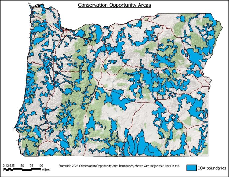
COAs are places where broad fish and wildlife conservation goals would best be met, and they have been designated for all ecoregions within Oregon’s SWAP except the Nearshore ecoregion. COAs were delineated through a spatial modeling analysis and expert biologist review (COA Methodology). Continuing the voluntary approach to SWAP implementation, conservation actions will likely be implemented within COAs by a variety of partners (e.g., landowners, land managers, agencies, watershed councils, local land trusts, Soil and Water Conservation Districts, etc.) and will encompass all types of land ownership and management approaches. COAs were developed to guide voluntary conservation actions in Oregon. Land use or other activities within these areas will not be subject to any new regulations. The COA map, dataset, and other underlying information should only be used in ways consistent with these intentions.
The Nearshore ecoregion does not include any COAs, as all land masses within the Nearshore ecoregion are protected lands. The Oregon Islands National Wildlife Refuge Wilderness Area spans the entire length of the Oregon coast, and all rocks and islands within the refuge are designated National Wilderness Areas. These areas provide critically important habitat for many of Oregon’s SGCN. In this ecoregion, conservation actions and investments can be focused in areas established under the Rocky Habitat Management Strategy, such as Marine Research Areas, Marine Gardens (Marine Education Areas), and Marine Conservation Areas, as well as other designated areas like Marine Reserves and Marine Protected Areas.
COAs were first developed in 2006 with the intention for them to be updated and revised with each iteration of the SWAP. The first revision of the COA process was completed in 2016 and in 2026, ODFW completed the second re-analysis of COAs, using new and updated science, data, and resources.
COA Summary
Conservation Opportunity Areas cover a total of 29,341 square miles, which is roughly 30 percent of the state of Oregon.
COA Profiles
All 204 COAs have an associated COA profile that provides information on local SWAP priorities. This information includes a list of observed SGCN, Key Habitats, special features, recommended conservation actions, local conservation plans, and potential conservation partners. Web links are provided, when possible, to assist users in locating more detailed information and guidance on local conservation priorities. These profiles are supporting materials for SWAP implementation and are maintained outside of the formal review process of the SWAP. Information presented in these profiles is updated as needed to ensure that profiles maintain their utility for users over time, serving as a tool to assist practitioners in how to best meet SWAP goals locally.
Protected Areas
During the SWAP revision process, efforts were made to improve how COAs work alongside Oregon’s existing protected areas. For example, restoration or enhancement projects may be restricted in federally designated wilderness areas, but these areas often provide protection of areas for SGCNs and Key Habitats. USGS GAP Status 1 lands, including designated wilderness areas and National Park properties, are locations with “permanent protection from conversion of natural land cover” and are managed to allow natural disturbance events to proceed without interference.
During the SWAP revision process, all GAP Status 1 lands were removed from ODFW COAs, with a focus instead placed on identifying COAs in locations directly adjacent to protected areas. The intention was to ensure that COAs remain areas where practitioners can take conservation action, while also building upon the existing permanent protections provided in GAP Status 1 lands in an effort to enhance connectivity of Key Habitats and SGCN.
Public Lands
Sixty-two percent of the lands within COAs are owned and managed by government agencies. The majority are federal lands (93 percent), with state lands accounting for 6 percent and the remaining 1 percent split among local government agencies. COA profiles include a Special Features section which highlights protected areas within each COA and links users to local conservation plans.
Urban Areas
Landscape features that increase livability for people also play an important role in sustaining native wildlife populations. Cities are often built in close proximity to features important to fish and wildlife habitats, such as the confluence of rivers. While urban development can fragment larger habitat areas, urban areas can contain key natural habitats and features that offer significant benefits to fish and wildlife.
The initial COA modeling process, undertaken in 2006, incorporated raw landscape development data, such as roads, census population areas, and Urban Growth Boundaries (UGBs) to avoid areas highly impacted by development. During the first COA revision in 2016, a focal area of the process was to improve how urban, or developed, areas were incorporated into the analysis. One improvement of the 2016 revised COA modeling process was the availability of species movement models developed by The Nature Conservancy (TNC). These models were generated using UGBs as well as transportation, transmission lines, and other development-related datasets, and they predicted the impact of developed areas on the ability of a species to move across the landscape. This allowed the 2016 COA re-analysis to focus on the impact of development to SGCN, rather than simply avoiding populated or developed lands.
The 2026 revision of COAs continued to emphasize the importance of including urban landscapes to help target conservation actions in developed areas and leveraged updated wildlife connectivity models developed by ODFW during the Oregon Connectivity Assessment and Mapping Project. More than 40% of the revised COAs (88 out of 204) include at least some land within a UGB, totaling over 330 square miles of urban areas included in COAs statewide. These urban COAs help to maintain fish and wildlife habitat and connectivity even within Oregon’s developed landscapes.