Background
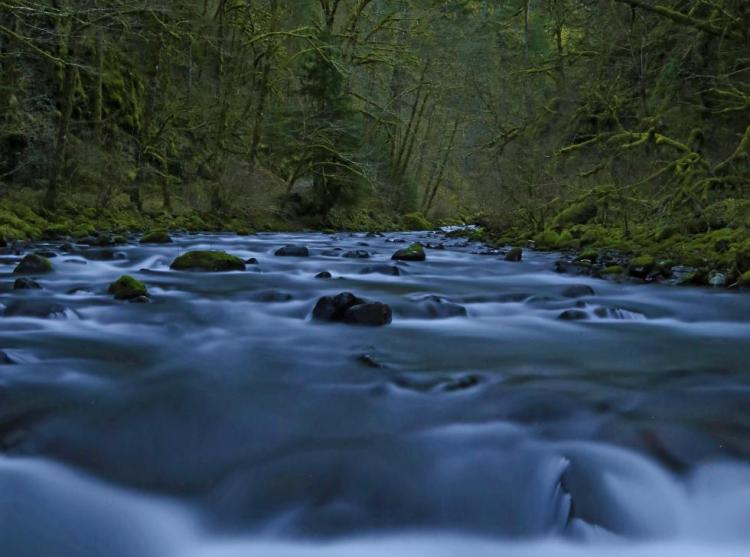
Oregon’s waters provide a wide range of ecological, economic, cultural, and spiritual benefits. Freshwater habitats contain significant biodiversity and support Oregon’s iconic fish and wildlife species. Ample clean water is critical for meeting the basic needs of organisms, like drinking water, and for supporting Oregon’s economy through irrigated agriculture, commercial fishing, industrial uses, recreation, and tourism. Healthy watersheds provide critical habitat and ecosystem services such as water purification, flood regulation, and carbon sequestration. Unfortunately, water quality and quantity are degraded or declining in many watersheds around the state and the ability of these freshwater systems to meet both human and ecosystem needs is at risk.
Humans have greatly modified freshwater systems by diverting water out of streams and damming, channelizing, or otherwise altering waterways to store water or prevent flooding. In combination with broadscale land use change, humans have degraded some Oregon watersheds to the point that they no longer function properly nor provide the ecosystem services they once did. Unnaturally low summer water levels due to diversions for out-of-stream uses can lead to reductions in available aquatic habitat, warmer stream temperatures, increased pollutant concentrations, and more frequent toxin-producing harmful algal blooms. Elevated water temperatures and reduced stream flows also increase susceptibility to and distribution of fish pathogens.
Climate change impacts, including shifting hydrological processes and increased demands on our limited water supply, put additional pressure on Oregon’s already stressed ecosystems. Oregon’s changing climate is expected to impact watershed health, hydrology, and water quality and quantity. This includes changes in precipitation patterns, air and water temperature fluctuations, shifts in snowmelt timing, and the increasing frequency of extreme weather events like floods, droughts, and wildfires (National Climate Assessment Report for the Pacific Northwest, the Oregon Climate Assessment Report). The droughts of the early 21st century have heightened awareness of the water quality and quantity implications of climate change. Ensuring sufficient amounts of high-quality water are available for aquatic ecosystems is a top concern for natural resource managers in western states facing the impacts of climate change and increasing water demand stemming from population growth.
Limited water supply intensifies concerns about water quality. When too much water is removed from a waterbody for out-of-stream uses, there is often not enough water remaining of sufficient quality to meet and maintain species’ habitat needs. In some cases, streams can dry up completely seasonally due to a combination of natural seasonal low flows and water extraction. Summer water temperatures are typically inversely correlated with streamflow, where low flows equate to high water temperatures. As streamflow declines due to diversions, groundwater pumping, and droughts, the impact of solar radiation on water temperature increases, often resulting in water temperatures elevated above species’ tolerances. This can be especially problematic during summer if temperatures rise to lethal levels in many parts of a stream and cold-water species do not have access to cold-water refugia .
Water quality is an important issue for all Species of Greatest Conservation Need (SGCN). For example, water quality issues in the Klamath Basin Wetlands, Lake Abert, Malheur Lake, and Summer Lake place an entire network of migratory bird habitats at risk. Additionally, elevated summer water temperatures impact juvenile rearing and over-summering conditions for many listed anadromous salmonids in the Columbia Basin. Throughout the Pacific Northwest, watershed health is directly related to healthy populations of migratory salmon and other native fishes and in Oregon, many measures of ecosystem performance, water quality, and watershed health have been linked to native salmonid populations.
Oregon’s Integrated Water Resources Strategy
Oregon’s statewide Integrated Water Resources Strategy (IWRS), adopted in 2012 and last updated in 2025, provides a blueprint to help the state better understand and meet its water needs, instream and out-of-stream, above and below ground, to achieve a secure water future for people and the environment. The strategy identifies a number of objectives and critical water-related issues that need to be addressed and offers recommended actions.
The Oregon Water Resources Department (OWRD), ODFW, and other agencies work closely together to meet the goals of the IWRS and promote public engagement.
Many of the actions identified in Oregon’s SWAP relate directly to actions identified in the IWRS. Both efforts call for actions to:
- prevent and eradicate invasive species
- protect and restore instream flows, habitat, and access for fish and wildlife
- incorporate land use changes and population growth in water planning activities
- address future climate conditions

Water Quality
Water quality standards are developed for individual parameters to protect beneficial uses of a water body such as fish and aquatic life, recreation, water supply, and agriculture. Water quality is measured through physical, chemical, and biological parameters including temperature, dissolved oxygen, pH, and turbidity (levels of fine suspended sediments and other particulate matter). In general, increased temperature, low dissolved oxygen, or high turbidity can indicate that water quality may be degraded and uses may not be fully supported. Both point and nonpoint source pollution, including toxic contaminants, mercury deposition, bacteria, and nutrients, can degrade water quality. A key component of water quality standards are anti-degradation provisions, which include the designation of Outstanding Resource Waters (ORWs). Outstanding Resource Waters may be designated for a variety of reasons, including high water quality, exceptional recreational or ecological significance, or critical habitat.
A major tool in identifying and prioritizing water quality problems is Oregon DEQ’s Integrated Report (published every 2 years) and list of impaired waters required under the federal Clean Water Act. This list of water bodies and stream reaches that do not meet water quality standards is updated approximately every two years.
The Oregon Water Quality Index (OWQI) is another method for quantifying water quality conditions using data from a network of 160 river and stream sites across the state. The OWQI is used to communicate information on the overall water quality of Oregon’s rivers in an easy-to-understand, non-technical manner. Water Quality Index scores range from 10 (poor water quality) to 100 (ideal water quality) and consider dissolved oxygen, biological oxygen demand, pH, ammonia and nitrate nitrogen, phosphorous, total solids, and bacteria levels. Although the OWQI produces a score describing general water quality for a particular monitoring site, additional information is required to assess impacts to human health, ecological health of aquatic systems, and the potential impacts of degraded water quality on fish and wildlife.
Oregon’s Existing Framework for Water Quality
State agencies that manage major water quality programs include DEQ, ODA, ODF, and ODFW.
Oregon Department of Environmental Quality – Water Quality Programs
Oregon DEQ is responsible for protecting the state’s surface waters and groundwater to keep them safe for a wide range of uses, such as drinking water, recreation, fish habitat, aquatic life, and irrigation.
DEQ’s water quality focus areas include:
- developing water quality standards
- monitoring and assessing water quality
- regulating sewage, industrial discharge, and injection systems
- permitting septic systems
- working with public drinking water systems
- providing grants and technical assistance to reduce nonpoint source pollution
- providing loans to communities to build treatment facilities
DEQ develops Total Maximum Daily Loads (TMDLs) as a primary approach to address water quality impairments. A TMDL is the calculated pollutant amount that a waterbody can receive and still meet water quality standards. Per an agreement with the EPA, the majority of TMDLs are prepared by DEQ and approved by the EPA for waterbodies in Oregon identified as water quality-limited and needing TMDLs (the 303(d) list). In 2022, the Oregon Environmental Quality Commission adopted rule amendments to allow TMDLs to be adopted by rule, in addition to issue by order.
TMDLs are waterbody-specific and consider seasonal variation of pollutants. They identify significant sources of pollution and then establish load allocations (portions of loading capacity to be allocated to existing nonpoint sources), wasteload allocations for point sources, and reserve capacity for the waterbody. Load allocations assigned to nonpoint sources in TMDLs are typically much lower than the current contributions of nonpoint sources to water pollution, particularly for bacteria, nutrients, and temperature. Wasteload allocations are implemented through revisions to effluent limits in permits. Because they are waterbody-specific, TMDLs consider individual basin hydrography, climate, streamflow, dam and reservoir operations, land use and ownership, and local fish and wildlife. Successful implementation of TMDLs includes issuing discharge permits that incorporate appropriate wasteload allocations and developing and implementing TMDL implementation plans as identified in the Water Quality Management Plans. The DEQ has developed guidance for state and local government designated management agencies and responsible parties for developing and implementing TMDL plans within their jurisdiction.
Oregon Department of Agriculture – Water Quality Plans and Rules
The Agricultural Water Quality Management Act was passed in 1993 and is the foundation of the ODA Agricultural Water Quality Management Program. ODA, in conjunction with local stakeholders, completed 38 basin-specific agricultural water quality plans throughout the state to identify goals, objectives, and recommended management practices for agricultural landowners to improve water quality. The plans are updated every two years and include area-specific rules that require certain conditions to be met by law on all agricultural lands. Basin-specific plans and rules provide for tailoring to local conditions and needs. Plans and rules address controlling sources of pollution from agricultural lands, including erosion and sediment transport control, animal waste management, nutrient management, irrigation water management, and riparian area management. Plans and rules focus on voluntary outcomes, allowing landowners to choose the best practices for their operation to comply with the rules. Although compliance with the rules is required, the focus is on voluntary solutions rather than enforcement. To meet the goals of the plans, landowners typically work with local Soil and Water Conservation Districts (SWCDs), the Natural Resources Conservation Service (NRCS) and Farm Service Agency, and ODA to implement conservation practices.
Oregon Department of Environmental Quality – Water Quality Programs
The Oregon Department of Forestry (ODF) manages state-owned forestlands in Oregon and administers the Forest Practices Act (FPA) on non-federal forestlands to ensure that water quality and resource protections are maintained during and after commercial forest operations.
Forests are an integral part of the water cycle in Oregon. Forest soils filter out substances such as mercury, pesticides and other pollutants as water passes through the forest ecosystem. Forest cover slows down erosion and delays the release of water into streams, helping to stabilize the quality and quantity of water in the area. The Private Forests and State Forests divisions ensure high water quality around the state by enforcing statutes and rules that protect drinking water and fish habitat from unnecessary human-caused impacts. ODF also conducts research and monitoring to verify that current forest management practices, and any new rules or policies, maintain water quality and fish habitat.
The Private Forest Accord (PFA) is an agreement between Oregon’s timber industry, the Oregon Small Woodlands Association, and prominent conservation and fishing organizations to modify portions of Oregon’s forest practice laws and regulations in a way that expands protections for fish and amphibians while also providing regulatory certainty for timber harvest and forest management. The changes to the Oregon Forest Practices Act are aimed at avoiding and minimizing effects of timber harvest and other private forest management activities on certain aquatic species and their habitats.
Updated Forest Practice Act rules associated with the Private Forest Accord agreement include:
- Increase stream buffers and enhance protections for streams.
- Create new design standards for forest roads including new requirements to inventory, maintain, and manage roads. Associated funds will be available to replace culverts on fish bearing streams and improve roads for small forestland owners.
- Retain more trees on steep slopes to improve slope stability, reduce sediment delivery to streams, and provide long-term fish habitat.
- Protect fish and amphibian habitat. Wider stream buffers will protect water quality and habitat for stream-dependent species such as salmon, steelhead, bull trout, and amphibians.
- Modify Oregon Department of Fish and Wildlife (ODFW) regulations for managing beavers.
- Invest in compliance monitoring to better evaluate landowner compliance.
- Set up an Adaptive Management Program to inform the Board of Forestry as it determines whether to adjust rules to meet the goals of the PFA Habitat Conservation Plan (HCP). The program includes a committee and independent research and science team to give science-based and technical information to help the Board of Forestry.
- Allocate funds to conduct rulemaking, update maps and databases, monitor forest practices, and administer the laws and programs.

Oregon Department of Fish and Wildlife Programs
The Water Program at ODFW participates in agency rulemaking processes, grant reviews, water use permit reviews, water quality management planning and implementation, and other relevant processes with state and federal agencies that have a regulatory nexus to water quality to ensure that decisions account for fish and wildlife needs.
Poor water quality is a major limiting factor in the recovery of many salmonid populations. For example, the Upper Willamette Chinook and Steelhead Recovery Plan identifies temperature and toxic contaminants as limiting factors for recovery. Elevated water temperatures result in reduced juvenile survival and growth, as well as higher pre-spawn mortality.
Review of mosquito abatement plans (i.e., pesticide use plans) also falls under ODFW’s jurisdiction. ODFW seeks to minimize effects on fish, wildlife, and their habitats while not significantly interfering with disease prevention and containment. ODFW considers mosquitoes to be an important part of the ecosystem, as they provide a prey base for many of Oregon’s native fish and wildlife during critical life stages, and natural predators of mosquitoes include many birds, bats, fish, amphibians, and insects. State statutes ORS 452.140 and ORS 452.245 direct vector control districts and counties to obtain ODFW approval before applying pesticides to control vectors. ODFW implements the statutes by reviewing and approving vector control plans annually. The approval process is described in ODFW’s Vector Control Guidance for Sensitive Areas.
ODFW guidance contains recommendations to avoid direct impacts of pesticide applications on fish, wildlife, or their habitats, as well as attempting to minimize indirect, chronic, and long-term impacts. ODFW’s approval only applies to defined and identified sensitive areas and species. ODFW has identified three categories of sensitive areas for the purposes of the guidance: 1) Wildlife Areas and Refuges, 2) Wetlands of Concern, and 3) Unique, Rare, or Vulnerable Habitats. Sensitive area maps are available on the ODFW website.
Water Quality: Goals and Actions
Goal 1: Protect, maintain, and restore water quality in surface and groundwater to support a healthy ecosystem, support aquatic life, and provide fish and wildlife habitat.
Action 1.1. Reduce runoff pollution.
In urban areas, increase cooperation between governments, watershed councils, and businesses to reduce impervious surfaces and direct runoff to water bodies. When constructing new roads, consider sediment catchment and removal in road design. Promote and permit “green infrastructure” that reduces runoff, such as disconnecting downspouts, installing green (“living”) roofs, and using permeable paving materials. Manage stormwater to minimize transfer of contaminants to streams. Restore riparian vegetation buffer strips and use native landscaping (e.g., ODFW’s Naturescaping) and bioswales to filter runoff. Continue ongoing water quality assessments and restoration programs.
In rural and agricultural areas, reduce erosion and transport of excess sediment into streams, for example, from gravel roads and other disturbed ground. Use conservation and best management practices such as no-till or conservation tillage, plant cover crops, maintain vegetated buffer strips between fields and waterbodies, restore healthy native riparian areas, cover and store animal waste in protected upland areas, provide off-channel watering for livestock, and keep livestock out of streams.

Action 1.2. Maintain and restore wetlands, floodplains, and riparian areas to increase filtration of sediments and contaminants, mitigate flood impacts, provide shade, prevent channel erosion, recharge groundwater aquifers, and maintain stream habitat features.
Restore wetlands and riparian areas to remove and prevent contaminants from entering surface water. Avoid removal of riparian vegetation and plant trees in riparian areas to maintain stream shade, mitigate stream temperature increases, and provide critical nutrients and forage for macroinvertebrates and the stream ecosystem. Implement stream restoration techniques that improve floodplain hydrologic connectivity and increase water storage capacity. Add wood to streams to improve channel stability and complexity, slow water movement, improve aquatic habitat, and increase resilience to both low and high flows. Reconnect stream channels to floodplains and maintain native plant species in riparian areas and wetlands to help to reduce flooding intensity. Restore native vegetation throughout the watershed to increase shade and reduce stream temperatures, maintain water infiltration and flow, prevent soil erosion, and prevent contaminants from entering aquatic systems.
Action 1.3. Implement water quality improvement projects and management frameworks.
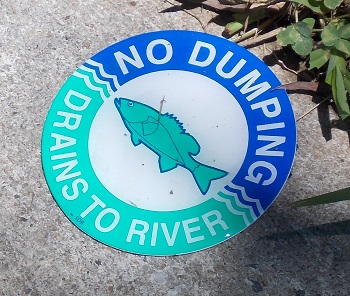
Use incentive programs, such as tax credits, pollution credits, and other tools to reduce the amount of contaminants entering waterways. In urban areas, continue educational efforts, such as “Dump No Waste – Drains to Stream” postings at sewer drains. Continue implementing DEQ’s TMDL planning and ODA Water Quality Management planning, which address water quality on a watershed basis, including nonpoint sources of contaminants. Manage for water quality within an adaptive management framework that incorporates new information and responds to emerging concerns. Consider water quality implications of water resources infrastructure (e.g., reservoirs) and develop management plans that ensure compliance with water quality standards.
Action 1.4. Monitor chemical, physical, and biological parameters of aquatic habitats for changes in water quality and to identify high quality and impaired waterbodies.
Promote statewide long-term water quality and quantity monitoring efforts, including for emerging contaminants (e.g., 6PPD-q). Incorporate national and regional program water quantity and quality indicators to assess ecological function (i.e., US Environmental Protection Agency, National Research Council, OR DEQ). Use of indicators can help characterize the status of waterways to better detect change and to diagnose the causes of change.

Examples of biological indicators include:
- Macroinvertebrate community indices (e.g., Multimetric Index, Observed/Expected ratio)
- Macroinvertebrate species richness, number of native taxa, relative abundance of sensitive taxa, biomass, productivity
- Salmonid population, structure, abundance, productivity, diversity
- Species interactions, including predation, competition, presence of invasive species
Examples of chemical indicators include:
- Nutrient levels
- Chlorophyll A/cyanotoxins
- Presence of specific toxic contaminants
- Mercury
Examples of physical indicators include:
- Water clarity
- pH
- Temperature
- Dissolved oxygen
- Total suspended solids
Guidelines for sampling protocols and methodology can be found through the DEQ and the U.S. EPA. Indices can be linked to specific stressors (Stressor ID) using a weight of evidence approach that combines existing data, literature, and scientific judgment to make predictions about ecological characteristics.
Identify Oregon’s cold-water refugia by continuing water temperature modeling and data collection efforts statewide. Work with other state agencies to identify approaches and implement protections for the state’s most critical cold-water resources.
Water Quantity
Under Oregon law, water is a public resource, meaning that all water belongs to the public. With some exceptions, cities, irrigators, businesses, and other water users must obtain a permit or license from the Oregon Water Resources Department (OWRD) to use water from any source, whether it is underground or from lakes or streams.
In many areas of the state, particularly during the summer, water supplies are fully allocated to out-of-stream uses, reducing instream flows to the point that they no longer provide quality habitat for Oregon’s fish and wildlife. Water is diverted out of rivers, streams, aquifers, and lakes for uses such as agriculture, municipal, industrial, and domestic water supplies, and power generation. Other physical alterations affecting flow and habitat access include natural and artificial barriers, wetland drainage, or channelization. The timing of water diversions and releases from reservoirs influence disturbance regimes, sediment and bedload transport, and groundwater storage and discharge. For example, the timing, location, and quantity of water released from dams can have negative or positive implications on available habitat and water temperature. Unnatural water fluctuations can impact fish and wildlife by altering the timing of fish migrations, dewatering fish eggs, or stranding fish in isolated pools. Increased groundwater pumping reduces groundwater discharge of cold water to rivers and streams, subsequently reducing the availability of both cold water refugia and suitable habitat for cold-water dependent species. Global processes, including climate change, influence temperature and precipitation patterns and can potentially affect runoff amounts and timing, aquifer recharge, and water supplies. Increasingly frequent multi-year droughts can have severe implications for water quantity as well as quality and can have long-term impacts that persist after the conclusion of official drought (e.g., reservoir refilling).
In Oregon, state agencies, including ODFW, DEQ, and the Oregon Parks and Recreation Department, can apply for instream water rights for the benefit of the people of the state of Oregon to legally protect water instream (i.e., within a stream channel or lake bed) for public uses such as protection of fish and wildlife, water quality, and recreation (adapted from the Instream Water Rights Act of 1987, ORS 537.332 – 537.360). Instream water rights are the state’s mechanism to provide water for healthy ecosystems that support multiple public uses by protecting the full suite of flows for fish and wildlife, water quality, recreation, and scenic attraction, as well as supporting cultural values and healthy economies. OWRD is the state agency responsible for protecting instream water rights in trust to support the public interest. ODFW applies for instream flows based on estimated monthly requirements to sustain healthy fish populations. Instream Water Right Rules (OAR 635-400) set the policy for ODFW’s instream water right applications, which are intended to protect flows instream for aquatic and fish life, wildlife, and their habitats. ODFW’s policy is to apply for instream water rights on waterways of the state to conserve, maintain, and enhance aquatic and fish life for present and future generations of Oregonians. The long-term goal of this policy is to obtain an instream water right on every waterway that has value to fish and wildlife.
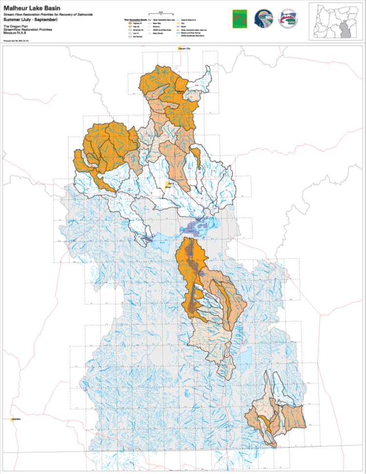
As part of the Oregon Plan for Salmon and Watersheds, ODFW and OWRD developed streamflow restoration priority maps from 1998-2001, showing flow restoration needs and priorities. The maps display each river basin, with rankings for streamflow restoration need, feasibility for streamflow restoration, and priorities for restoration. These prioritization maps and additional information, including a summary of the prioritization process and the criteria used to establish the priorities, are available in the ODFW Data Clearinghouse, with summer priorities provided as a layer within the ODFW Compass mapping tool. ODFW has also developed a tool to identify Aquatic Habitat Prioritization for flow protection and restoration.
Water Quantity: Goals and Actions
Goal 2: Conserve, protect, maintain, and restore surface flows and groundwater levels to support healthy SGCN and Key Habitats. Seek opportunities to conserve, maintain, and restore streamflow and lake levels, as well as groundwater and spring-fed ecosystems that provide cold water refugia for SGCN.
Action 2.1. Work with agencies, tribes, conservation groups, water users, and other organizations to establish priorities, develop tools, and implement projects that maintain, protect, or restore stream flows.
Conduct instream flow studies to develop ecological flow targets and apply for associated instream water rights. Identify and protect the state’s cold-water resources. Conduct real-time flow and temperature monitoring in priority areas. Identify priority locations for instream transfers and leases and other voluntary flow restoration efforts. Work with water users and conservation groups to actively restore streamflow in priority areas using voluntary market-based agreements. Promote water management actions that enable climate resilience and adaptation. Engage with regulatory agencies to ensure consideration of fish and wildlife needs in water right and hydropower processes. Continue to develop methods to determine if sufficient water supplies exist to maintain ecological functions that support SGCN, and further identify when conservation actions may be needed. Protect stream flows from further decline in areas not meeting fish and wildlife habitat needs. Collaborate with ongoing water quantity efforts taking place under the Oregon Plan (Oregon Watershed Enhancement Board). Further collaborative water planning and implementation processes to secure balanced solutions for water management (e.g., water markets, water banks, and incentive programs). Engage local communities, stakeholders, and tribes in watershed management decisions to understand the value of traditional knowledge, foster partnerships, and ensure that management plans are inclusive and equitable. Use voluntary conservation tools, such as the Allocation of Conserved Water Program. Work with OWRD to ensure instream water rights are adequately monitored and protected. Identify and protect cold water rearing and refugia habitat for SGCN (e.g., Cold Water Refugia and Core Cold Water Habitat Use designations by the Oregon Department of Environmental Quality).
Action 2.2. Maintain and protect groundwater and seek opportunities to enhance aquifer recharge.
Protect aquifers from further decline. Seek opportunities for aquifer recharge that restores groundwater to sustain surface flows and groundwater-dependent ecosystems. For example, restore floodplain function and restore wetlands to allow for greater water infiltration. Continue implementation of Oregon’s Groundwater Quality Protection Act.
Action 2.3. Use established indicators to monitor watershed function and determine thresholds for action.
Monitor water quantity and quality to better understand watershed function and processes and guide restoration. Promote expansion of real-time water quantity and quality monitoring gage network throughout the state. Incorporate integrated hydrologic and water quality models, habitat equivalency, and net environmental benefit models, and use habitat characteristics to predict ecological changes that might result from proposed hydrologic alterations. Use the existing indicators for watershed health, to measure ecological function.
These indicators include:
- altered hydrology
- floodplain presence and connectivity
- groundwater availability
- riparian condition (e.g., width, composition, fragmentation)
- stream connectivity
- channel condition
- habitat structure (e.g., habitat types, bank erosion, channel substrate, off channel habitat, large wood).
Continued use of these indicators, along with actions to address watershed function issues, will ensure that watersheds provide vital ecological services to humans, fish, and wildlife.

Additional Resources
The National Climate Assessment, 2018: “Significant changes in water quantity and quality are evident across the country. These changes, which are expected to persist, present an ongoing risk to coupled human and natural systems and related ecosystem services. Variable precipitation and rising temperature are intensifying droughts, increasing heavy downpours, and reducing snowpack. Reduced snow-to-rain ratios are leading to significant differences between the timing of water supply and demand. Groundwater depletion is exacerbating drought risk. Surface water quality is declining as water temperature increases and more frequent high-intensity rainfall events mobilize pollutants such as sediments and nutrients” (Chapter 3: Water, Key Message 1: Water Quantity and Quality).
Willamette Water 2100: This project evaluated how climate change, population growth, and economic growth would alter the availability and the use of water in the Willamette River Basin on a decadal to centennial timescale. The five-year project began in October 2010 and was a collaborative effort of faculty from Oregon State University, the University of Oregon, and Portland State University, and was funded by the National Science Foundation. The project developed tools to help foster understanding of water scarcity and inform water system management.
DEQ’s Water Quality Trading Program
Department of State Lands Mitigation Guidance